RegionChooser
RegionChooser is a Java project. Its graphical interface allows to extract a specific region from multiple CityGML files and save it as a smaller CityGML file.
It uses:
- Java 17
- JavaFX
- Openlayers
RegionChooser was developed during SimStadt & SimStadt II projects.
Installation
The easiest way to install RegionChooser is to install SimStadt.
RegionChooser executables are packaged inside SimStadt.zip file.
Usage
Select a repository
You first need to run SimStadt in order to select a repository. Once a repository is selected, SimStadt can be closed.
Start RegionChooser
RegionChooser.batin Windows./RegionChooser.shin Linux./RegionChooser.commandin macOS
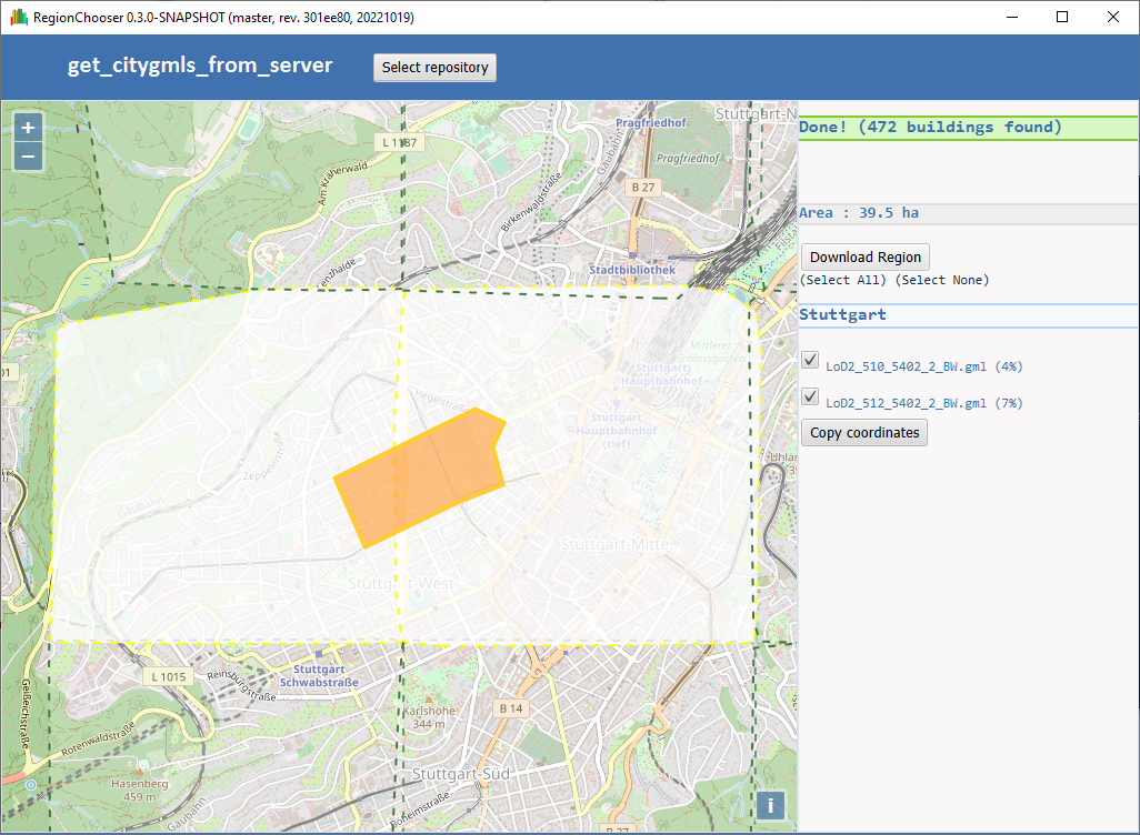
Select a region
- Once a repository has been imported, a map should be shown with the convex hulls of the available CityGML files.
- It is possible to define a polygon by clicking repeatedly on the map.
- If an intersection is found with at least one CityGML file, a list of files will be shown on the right.
- The selection might intersect multiple files. The user can select the desired files.
- By clicking on
Download Region, a new CityGML file will be created, by merging the intersections of the polygon with each selected CityGML file.
Get coordinates of polygon
The coordinates of the currently drawn polygon can be exported to WKT by clicking on Copy coordinates. It can be useful for further processing, e.g. in a Python script.
As an example:
POLYGON((9.176194 48.779168, 9.171473 48.775265, 9.176923 48.772890, 9.179842 48.774474, 9.181043 48.774134, 9.183103 48.775661, 9.182073 48.776962, 9.176194 48.779168))
Command-line
RegionChooser can also be called from the command-line:
Launching RegionChooserCLI --help
Usage: region_chooser [-hlV] [--get-hull] [-e=31467] [-o=output.gml]
                      [-w=polygon.wkt] -i=input.gml[,input.gml...] [-i=input.gml
                      [,input.gml...]]...
Extracts a region from one or more citygmls, or calculates the convex hull.
  -i, --input=input.gml[,input.gml...]
                            Citygml files to extract from
  -o, --output=output.gml   Output file
  -e, --epsg=31467          EPSG id for coordinate reference system.
                            Will use the one from input.gml if unspecified.
  -l, --local               Are WKT coordinates in local CRS?
                            Coordinates are in WGS84 if unspecified.
  -w, --wkt=polygon.wkt     File containing WKT polygon, or - for stdin
      --get-hull            Calculate the convex hull of the input CityGML files
  -h, --help                Show this help message and exit.
  -V, --version             Print version information and exit.
As an example:
SimStadt.bat
     --input Grombühl.proj\LoD2_32_566_5516_2_BY.gml,Grombühl.proj\LoD2_32_568_5516_2_BY.gml,Grombühl.proj\LoD2_32_570_5516_2_BY.gml
     --output Grombühl.proj\Grombühl.gml --wkt "POLYGON((9.920858224863567 49.807325539080495, 9.918540796274696 49.79447295986074, 9.992612680429975 49.79358644932381, 9.991926034922162 49.807325539080495, 9.920858224863567 49.807325539080495))"
./SimStadt.sh --get-hull --input example.gml
Development
In order to compile, test and install RegionChooser into your local Maven repository:
git clone https://transfer.hft-stuttgart.de/gitlab/hft_gitlab/regionchooser.git
cd regionchooser
mvn clean install
The RegionChooser jar will then be available to SimStadt for packaging, when a SimStadt+RegionChooser bundle is created.
Author
Eric Duminil, HfT Stuttgart
Contributors
Matthias Betz, HfT Stuttgart